


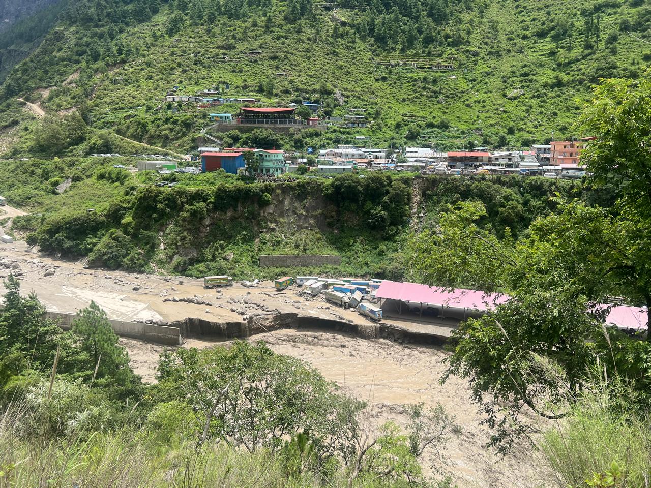


Kathmandu. The International Centre for Integrated Mountain Development (ICIMOD), an organization related to climate change studies, has said that it is too early to confirm the cause of the flood in the Rasuwa Bhotekoshi River on Tuesday morning.
Isimod said it was too early to confirm the cause, but claimed that the floods were caused only by rain in the upper reaches.


Isimod said it would have to wait for some time until the monsoon clouds clear and the sky opened to get a clear satellite image for a detailed analysis as extensive research is needed to confirm this.
ICIMOD has pointed out the need for a multi-disciplinary team comprising geologists, glaciologists, hydropower experts and remote sensing analysts to conduct a joint study to determine the exact cause of the flood in Rasuwa.
Isimod has put forward some questions saying that the severe floods in Rasuwa have raised many questions.
Did the flood cause the glacial lake to burst? If yes, which lake was there?
Although it is suspected that the glacial lake burst and flooded due to floods or landslides, there is no conclusive evidence so far. Isimod’s 2021 list shows that a glacial lake in the upper part of the Trishuli River in China’s Tibetan Autonomous Region has been classified as high-risk. Where close monitoring is required.
Recent studies have shown that between 1990 and 2020, the size of glacial lakes in the basin increased by 33 percent and the number by 16 percent. Recent satellite images taken before the flooding have also shown an increase in the number of glacial lakes.
Since cloud cover has hampered optical satellite analysis, it is mandatory to wait until the sky clears to verify whether any of these lakes have collapsed or whether there has been a sudden change in the volume of the lake, ICIMOD said.
Was a dam on a river/stream and then released as a flood? If so, in which river/stream?
Preliminary reports and social media visuals suggest the origin of the Lande Khola, a tributary flowing east of the Bhotekoshi River of Kerung, Rasuwa (one of the major tributaries of the Trishuli River). However, the water level data of the Department of Hydrology and Meteorology show no signs of temporary dams or sudden collapses, such as a rapid rise of water in the upper reaches and then rapid flow. This indicates that dam construction on the river may not be the cause, although further upper field verification is needed to arrive at a definite conclusion.
Was there heavy rainfall in the Chinese region? If so, what was the nature of the rain?
According to a preliminary analysis by ICIMOD, global and regional weather forecasting systems, including ISIMOD’s high-impact weather assessment toolkit, the National Oceanic and Atmospheric Administration’s Global Forecasting System, the European Center’s Mid-Range Weather Forecasting, icosahedral nonhydrostatic weather models, as well as nearby real-time satellite rainfall products, do not indicate significant rainfall in Chinese catchments in the upper reaches in the days before the flood. This indicates that excessive rainfall was not the main cause of floods in Bhotekoshi and Trishuli.
ICIMOD said the findings were based on a study conducted by Senior Hydrology Research Associate Pradeep Man Dangol.